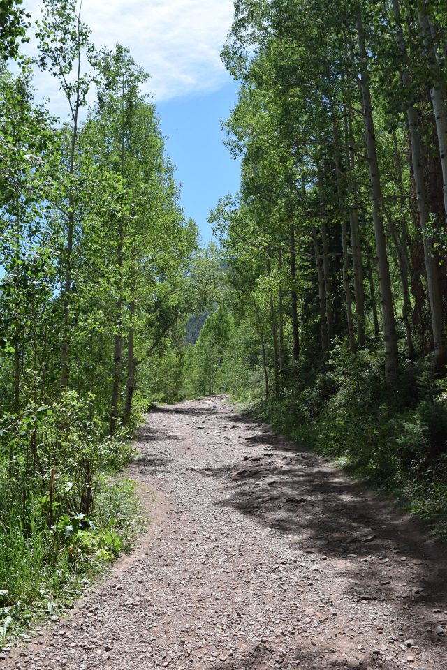
One of the more popular hiking trails near Telluride in Colorado is the Bear Creek Trail. It is popular for a variety of reasons, its proximity to town, the moderate incline, wildflowers, and the stream that runs next to the trail. Like any hiking in the Colorado high country, it is important to drink plenty of water as well as to be aware of the altitude and pace yourself. The trail is nice and wide, which also means that there is plenty of sunshine that can make it a hot hike on a summer day.
Aspen Trees Along the TrailViews of Bear CreekEnjoying Our HikeDramatic SceneryWildflowers
The trail winds its way amongst the groves of Aspen trees as it climbs its way for an elevation gain of a little over a thousand feet (300 meters). Although there aren’t many views of Telluride from the trail, the mountain peaks are visible from many locations on the trail making for some dramatic scenery. Because of its popularity, there will be many other hikers on the trail with you making the chances of seeing wildlife slim and perhaps not as much of an escape into nature as some other trails.
Looking Up Through an Aspen GroveGorgeous Vistas Pond with a Beaver Dam Just Outside of TellurideStart of the TrailBeautiful Views from the Trail
This was one of our first hikes of the season due to the fact that we haven’t been able to get out as much, so it felt really good to get out on a trail and hike for a few hours. With so many trails to choose from in the area, it is hard not to find one that meets your hiking skill and endurance level. The trail is considered to be moderate, but when hiking in the mountains, there are always going to be strenuous sections with some steep inclines. Hiking Bear Creek Trail was certainly a great way to start our stay in Telluride.
Walking Along the Creek“Chimney Rock” on the CliffMountain SummitRelaxing HikeSummit in the Distance at the Start of the Hike
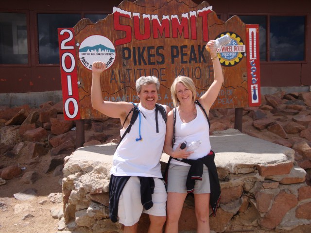
Barr trail starts in the town of Manitou Springs, which is located just outside of Colorado Springs, and quickly ascends into the Pike National Forest. Many people will hike or jog up the “Incline”, which is a steep trail that connects to Barr trail, so for the initial part of the hike, you will likely have many people running down as you hike up. The runners aren’t always in complete control of themselves, so you will find yourself stepping out of their way quite often. We have hiked the lower portion of Barr trail many times, but we only hiked the full trail that ends at the summit of Pikes Peak once. It was definitely one of the most difficult hikes that we’ve ever done due to both the length of the hike as well as the elevation gain.
Early in the Hike
Sign on Barr Trail, about 3 miles into the hike
View of Pikes Peak from Barr Trail
Lower Barr Trail
The entire hike is over twelve miles and has an elevation gain of over 7,000 feet (2,100 meters) to the peak, which is at 14,114 (4,301 meters). It certainly is not a hike for novices and was very much a challenge for us and we hike on a routine basis. Even if you are an experienced hiker, it is important to acclimate to the altitude of Colorado Springs for at least a couple of days before attempting to do the hike. Choosing the time of year to do the hike is important because even in the middle of summer it can snow on the top of Pikes Peak, so we hiked in August on a day when we knew that the temperatures would be fine at the base as well as the summit. Depending on the day, you may find yourself starting out in light weight clothing at the base and then layering up as you near the summit. It is also extremely important to be sure to stay hydrated with a combination of plain water and sports drinks.
Steep Hike at Points
Barr Trail at Tree Line
So Close and Yet So Far
View from Barr Trail, Garden of the Gods at the Base of the Mountain
Sign for the Summit
The hardest part of the trail was when we reached the tree line at 11,000 feet (3,350 meters) and the air thins out. The Summit House sits on top of Pikes Peak and is a restaurant and souvenir shop, which is visible from the base on a clear day. Once you reach the tree line, the point where the air is too thin for plants to grow, the Summit House seems like it should be close, but it is still a couple of hours away. Although we originally intended to hike up and then back down, it took longer to reach the summit that we anticipated, so we took the Cog Railway back down. The total hike to the summit took us about 8 hours, although we took our time and paced ourselves.
During our trip to Cochabamba, Bolivia a few years ago, we met Remy, who guided us on several different expeditions in the area. We are pleased to consider him a friend to this very day and continue to keep in touch. This article is a description of one of his tours, not one that we took, to the summit of Pico Tunari, the highest point in Cochabamba. Bolivia has one of the most stable mountain outdoor weather in the world, making it a great place for mountain trekking. If you visit Bolivia, we highly recommend using a guide, especially Remy (El Mundo Verde Travel).
We left early in the morning on the road to the villages Tiquipaya and El Paso, where we made a very interesting stop at the oldest church of Cochabamba. As a guide, I enjoy being able to explain many interesting things about the old history of the monument. Back on the road again the landscape changed quickly as we drove into the Tunari mountain range. On our journey we saw beautiful waterfalls, Andean lakes, farm lands, and encountered indigenes communities. The scenery was typical of the Andes landscapes and we stopped a few times in order to explain more about the country of Bolivia, which I’m passionate about, and the region that we were traveling through.
Our trekking began at a beautiful Andean lake called Laguna Taquiña, but before walking, I explained the practical things about walking in this altitude, 4300 meters above sea level, about the weather in the Majestic Andes, and the animals living in the region. We received a typical breakfast Api, a drink made out of corn that dates back from the times of the Incas, snacks, water, fruits and were ready to go!
Directly at the beginning of our hike there where two giant Andean Condors flying over our heads, the biggest flying creature in the world, how lucky we were!!!! We were also surrounded by hundreds of very curious llamas and Alpacas, many of them with little baby llamas. The trekking slightly ascends, we had beautiful weather and even a bit of snow on the mountaintops in the distance, which was really spectacular. You have the time to walk at your own pace, which makes this hike really nice and we took the time for the group to take pictures. At one point I took some stones from the ground and explained that there are incredibly old fossils in them. And yes indeed, we could see the shells all over the place, which was just unbelievable standing at almost 5000 meters above sea level. These fossils are between 500 and 600 million years old!!! Once there was an old ocean just where we are walking right now!
We hiked higher and higher and the trekking also became more and more strenuous. It’s just a fascinating feeling to hike at this incredible altitude, with landscapes around you like you are in a National Geographic documentary!! After trekking for about 3 hours, we finally reached our goal, and we stood at 5050 meters high (16404 feet). The view on the top was incredible, with hundreds of snowy mountain tops and endless views over the Andes. We were even able to see the Cordillera Real of La Paz, including the Illimani Mountain, 150 miles away! And of course we had a view of the city Cochabamba. On our way back we took a completely different trail and were able to see Vichachas, very funny animals, some kind of mix between a rabbit, squirrel and a kangaroo, it’s a typical animal from the Andes.
We came across some other unexplainable impressive viewpoints over this mountain range, and saw some other lakes with beautiful colors. We took a little rest at the Macho Lake, there was no sound at all, no cars, no planes flying over, no other trekkers, absolutely nothing, you are completely alone with Nature!
We were happy to be back at our 4 wheel drive vehicle, exhausted, the trekking itself was tough, but absolutely worth it, what a day we will never forget and recommend to all of you!!!!!


 We left early in the morning on the road to the villages Tiquipaya and El Paso, where we made a very interesting stop at the oldest church of Cochabamba. As a guide, I enjoy being able to explain many interesting things about the old history of the monument. Back on the road again the landscape changed quickly as we drove into the Tunari mountain range. On our journey we saw beautiful waterfalls, Andean lakes, farm lands, and encountered indigenes communities. The scenery was typical of the Andes landscapes and we stopped a few times in order to explain more about the country of Bolivia, which I’m passionate about, and the region that we were traveling through.
 Our trekking began at a beautiful Andean lake called Laguna Taquiña, but before walking, I explained the practical things about walking in this altitude, 4300 meters above sea level, about the weather in the Majestic Andes, and the animals living in the region. We received a typical breakfast Api, a drink made out of corn that dates back from the times of the Incas, snacks, water, fruits and were ready to go!
 Directly at the beginning of our hike there where two giant Andean Condors flying over our heads, the biggest flying creature in the world, how lucky we were!!!! We were also surrounded by hundreds of very curious llamas and Alpacas, many of them with little baby llamas. The trekking slightly ascends, we had beautiful weather and even a bit of snow on the mountaintops in the distance, which was really spectacular. You have the time to walk at your own pace, which makes this hike really nice and we took the time for the group to take pictures. At one point I took some stones from the ground and explained that there are incredibly old fossils in them. And yes indeed, we could see the shells all over the place, which was just unbelievable standing at almost 5000 meters above sea level. These fossils are between 500 and 600 million years old!!! Once there was an old ocean just where we are walking right now!
 We hiked higher and higher and the trekking also became more and more strenuous. It’s just a fascinating feeling to hike at this incredible altitude, with landscapes around you like you are in a National Geographic documentary!! After trekking for about 3 hours, we finally reached our goal, and we stood at 5050 meters high (16404 feet). The view on the top was incredible, with hundreds of snowy mountain tops and endless views over the Andes. We were even able to see the Cordillera Real of La Paz, including the Illimani Mountain, 150 miles away! And of course we had a view of the city Cochabamba. On our way back we took a completely different trail and were able to see Vichachas, very funny animals, some kind of mix between a rabbit, squirrel and a kangaroo, it’s a typical animal from the Andes.
 We came across some other unexplainable impressive viewpoints over this mountain range, and saw some other lakes with beautiful colors. We took a little rest at the Macho Lake, there was no sound at all, no cars, no planes flying over, no other trekkers, absolutely nothing, you are completely alone with Nature!
